Last Updated: 31-MAY-2022
_______________
Click on image to enlarge
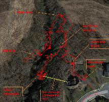
29-MAR-2022 GPS track. GPS here is not as accurate due to signal attenuation from eastern located satellites.
Looking at the three walks in this area.
The red track was 29-MAR-2022 The green track was when Ken & Mary walked across the stream on 28-FEB-2022. Due to GPS look angles this path representation is the most accurate. The Yellow track was our first walk on 17-FEB-2022. Again GPS errors were caused by the hill.
165 feet between red & yellow track.
Photos from 29-MAR-2022 visit
Photos from left to right of rock face
Stiched photos of shots above
Top of rock face
Water was less than a foot deep
Looking at Codorus Creek from site
Tom's photos
Photos from 28-FEB-2022 visit
Looking at spoil area in creek from first cave / mine site visited
Mine visited on 29-MAR-2022. Spoil area on hill right of tree on stream bank
Cave / mine site from across creek
Looking downstream from site
Photos from 17-FEB-2022 visit